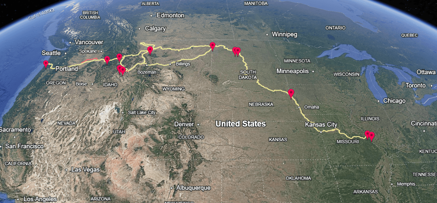
Posted by Teddy BurkhardtJan 14Explore Lewis and Clark's 8,000-mile journey in Google Earth.Show 3 more findings ZoomPBShttps://www.pbslearningmedia.org/asset/lewis-clark-google-earth/EN/
Posted by Teddy BurkhardtJan 14The Lewis and Clark expedition lasted over two yearsThe Corps of Discovery departed St. Louis in May 1804 and returned in September 1806, covering more than 8,000 miles by boat, horseback, and on foot. See a timeline of the journey’s key events.Britannicahttps://www.britannica.com/summary/Lewis-and-Clark-Expedition-Timeline
Posted by Teddy BurkhardtJan 14Lewis and Clark’s journey became a blueprint for future explorationCombining science, diplomacy, and logistics, the Corps of Discovery created a model for later expeditions—from charting the Arctic to NASA’s space missions.Smithsonian Magazinehttps://www.smithsonianmag.com/science-nature/lessons-in-space-exploration-from-lewis-and-clark-3174104/
Posted by Teddy BurkhardtJan 14Jefferson sent Lewis and Clark to map, trade, and secure the WestBeyond seeking a water route to the Pacific, Jefferson tasked the Corps of Discovery with mapping the new Louisiana Territory, cataloging its resources, and establishing trade with Native nations.https://www.monticello.org/thomas-jefferson/louisiana-lewis-clark/origins-of-the-expedition/
Posted by Teddy BurkhardtJan 14Jefferson’s Lewis and Clark expedition joined the centuries-long hunt for Northwest PassageFor centuries, leaders pursued a direct seafaring trade route from Europe to Asia. Jefferson joined this quest by sending Lewis and Clark west, though they confirmed no such practical interior route existed across the continent. 3:40https://www.youtube.com/watch?v=6bzdHyoK1Nk
Posted by Teddy BurkhardtJan 14The expedition produced the first detailed climate records of the WestLewis and Clark logged daily temperature, weather, and seasonal patterns throughout their journey, creating the earliest systematic meteorological record for the western territories of the United States. Their observations helped overturn longstanding views that weather west of the Appalachians was similar to the East Coast.https://lewis-clark.org/sciences/age-of-enlightenment/weather/
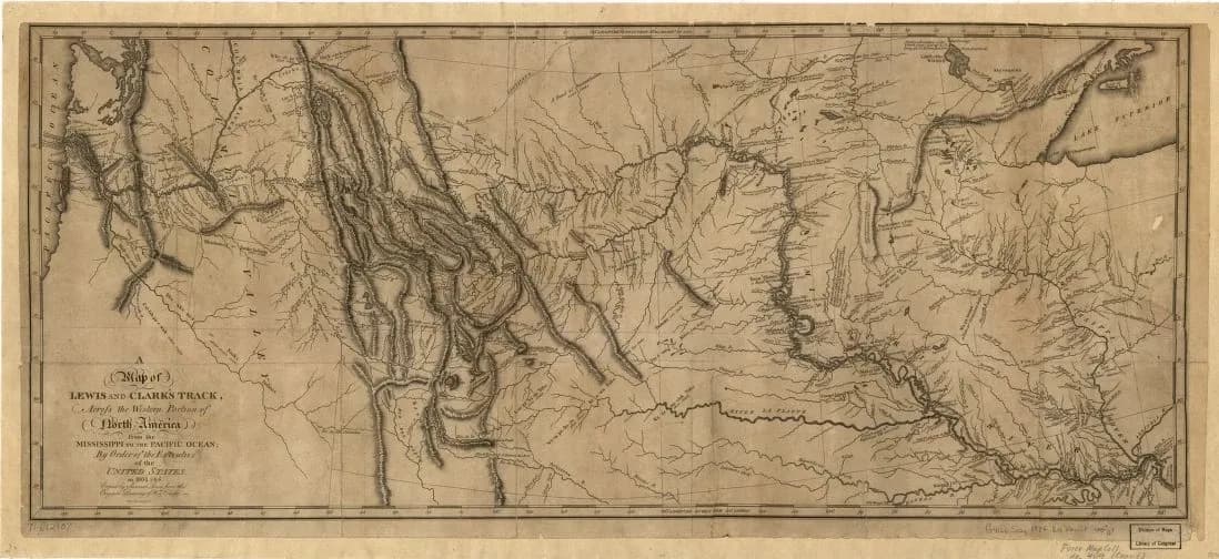
Posted by Teddy BurkhardtJan 14Clark’s maps provided the first detailed record of the American WestCovering over 8,000 miles, William Clark’s maps charted rivers, mountains, and tribal territories with remarkable accuracy. Equipped with sextants, compasses, telescopes, and more, Clark became an expert at surveying—requiring extensive celestial and topographical observations each day. ZoomNational Park Servicehttps://www.nps.gov/articles/william_clark_cartographer.htm
Posted by Teddy BurkhardtJan 14The Corps of Discovery braved wildlife, weather, and near-starvationAlong their 8,000-mile trek through territory populated by tribes suspicious of their intentions, Lewis and Clark’s party faced many dangers—including grizzly bear attacks, freezing winters, treacherous river crossings, and periods of near-starvation. Watch a 30-minute elaboration of their heroic efforts here. 30:11https://www.youtube.com/watch?v=ouGw6OojVE0&t
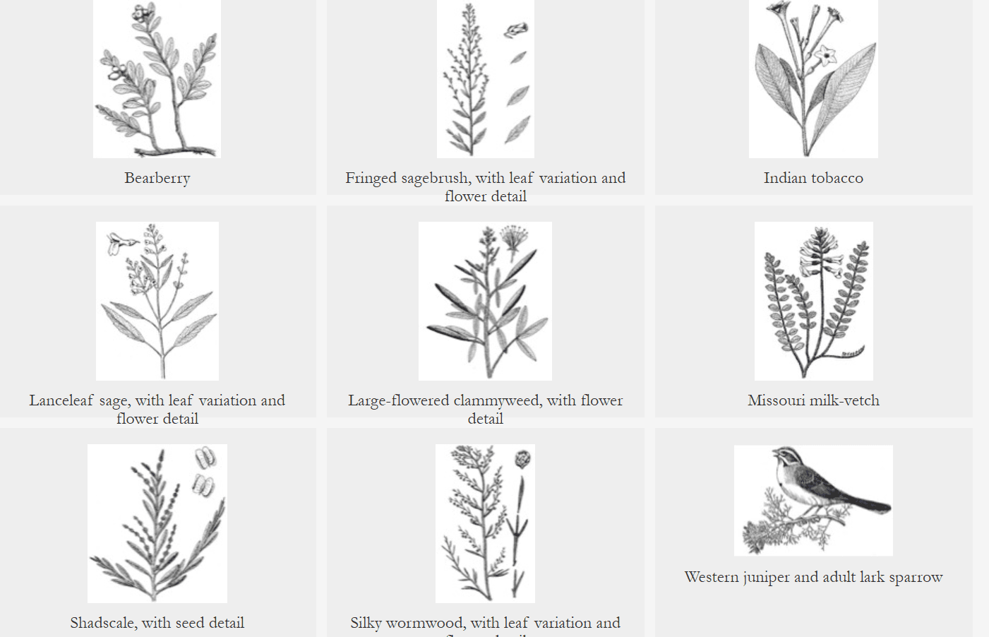
Posted by Teddy BurkhardtJan 14The expedition documented 240 plant species, 178 new to western scienceLewis and Clark’s botanical records introduced species to Americans like bitterroot, ponderosa pine, and Oregon grape—plants unknown to western science at the time. See a selection of these species in this image gallery. Zoomhttps://lewisandclarkjournals.unl.edu/images/plants_animals
Posted by Teddy BurkhardtJan 14Discover the 'American Serengeti' Lewis and Clark first recordedThis podcast traces the 19th-century exploration of the Great Plains' biodiversity—beginning with Lewis and Clark's wildlife cataloging and continuing through a century of documenting the Natural West's remarkable species and landscapes. https://open.spotify.com/episode/62Kvi9Uk0IStpuTp5utyGZ
Posted by Teddy BurkhardtJan 14Lewis and Clark identified 122 animal species new to science.Show 3 more findingsLewis and Clark's Travels Included Dozens of Astonishing Animal Encounters | HISTORYHISTORYhttps://www.history.com/articles/lewis-and-clark-animals-american-west
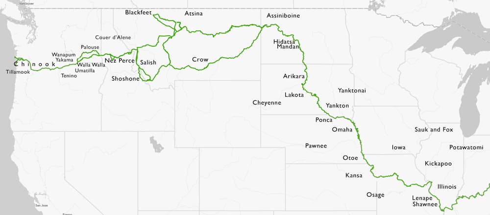
Posted by Teddy BurkhardtJan 14Lewis and Clark encountered more than 70 Native tribes during their journeyThe Corps of Discovery’s diplomacy ranged from peaceful trade and vital aid from tribes like the Shoshone and Nez Perce to tense standoffs, most notably with the Teton Sioux, who nearly brought the expedition to a halt. Zoomhttps://lewis-clark.org/primary/native-nations/
Posted by Teddy BurkhardtJan 15Jefferson omitted a plan to go beyond the Louisiana Territory in his funding requestIn January of 1803, the president sought $2,500 to fund the expedition (though it likely cost closer to $50,000). The ostensible rationale for the journey was to explore the newly purchased territory, but Jefferson did not mention he wanted Lewis and Clark to go beyond the newly acquired territory for several reasons.President Jefferson requests funding for Lewis and Clark expedition | January 18, 1803 | HISTORYHISTORYhttps://www.history.com/this-day-in-history/january-18/jefferson-requests-funding-for-lewis-and-clark-expedition
Posted by Teddy BurkhardtJan 14Native voices share their histories along the Lewis and Clark National Historic TrailTribal historians recount their peoples' histories and perspectives on the Lewis and Clark expedition, offering an Indigenous narrative of the lands, encounters, and legacies that shaped the journey. 35:51https://www.youtube.com/watch?v=M8SMOQSBDm8
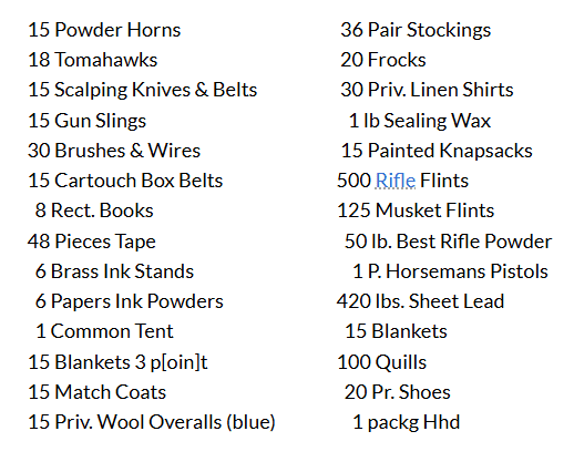
Posted by Teddy BurkhardtJan 14The Lewis and Clark expedition purchased more than 260 separate items to supply their journey.Show 3 more findings Zoomhttps://lewis-clark.org/the-trail/eastern-beginnings/lewis-in-philadelphia/outfitting-the-expedition/
Posted by Teddy BurkhardtJan 14William Clark negotiated one-tenth of all ratified treaties between Native Americans and the US.Show 2 more findingsBritannicahttps://www.britannica.com/biography/William-Clark
Posted by Teddy BurkhardtJan 14The Lewis and Clark Expedition unexpectedly ran into Sacagawea's long-lost family in the Rocky Mountains.Show 3 more findings ZoomA Bittersweet HomecomingSmithsonian Magazinehttps://www.smithsonianmag.com/history/a-bittersweet-homecoming-82872129/
Posted by Teddy BurkhardtJan 14The Lewis and Clark Expedition brought along an estimated 120 gallons of whiskey and still ran out of alcohol halfway through the journey.Show 3 more findings ZoomTheCollectorhttps://www.thecollector.com/surprising-gifts-brought-on-lewis-and-clark-expedition/
Posted by Teddy BurkhardtMar 5A free archive of firsthand historical documents from explorers of AmericaMaintained by the Wisconsin Historical Society, the American Journeys collection contains more than 18,000 pages of primary source documents—journals, letters, maps, and accounts written between roughly 1000 CE and the early 1800s. These include eyewitness records of the Norse arrival in North America, Spanish conquistador expeditions, and the Lewis and Clark journey. Browse this list of highlights where pages from the original texts are specified (clicking a link opens a PDF). American Journeyshttps://www.americanjourneys.org/highlights.asp
Posted by Teddy BurkhardtJan 14Meriwether Lewis grew up in the same neighborhood as JeffersonHailing from Jefferson’s Albemarle County neighborhood in Virginia, Lewis was a trusted aide and former Army officer. After leading the Corps of Discovery, he became Louisiana Territory governor in 1806, dying three years later under mysterious circumstances.National Park Servicehttps://www.nps.gov/lecl/learn/historyculture/meriwether-lewis.htm
Posted by Teddy BurkhardtJan 14Lewis brought his loyal Newfoundland dog on the expeditionMeriwether Lewis was accompanied by his dog, Seaman, a Newfoundland who traveled the entire journey—helping hunt, guarding camp, and even rescuing supplies from a river. 15:00https://www.youtube.com/watch?v=4QxOEXIikls
Posted by Marco Daniel MachadoSep 26, 2025The first women to run the Colorado River discovered four plant speciesOver 45 days and 660 miles, Elzada Clover and Lois Jotter identified more than 50 species in what was the first botanical survey of the region. Expected to help navigate boats and cook for the crew during the day, their work was confined to before dawn and after dusk.The Historic Grand Canyon Adventure Two Women Had for ScienceAtlas Obscurahttps://www.atlasobscura.com/articles/grand-canyon-plants-botany-elzada-clover-lois-jotter
Posted by Teddy BurkhardtJan 14The expedition included Clark’s enslaved servant, YorkYork, Clark’s enslaved servant, played a full role in the expedition—hunting, scouting, and aiding diplomacy with Native nations who were fascinated by his appearance. Despite his contributions, York remained enslaved for some time after the journey, though its uncertain if he remained so for the rest of his life. Explore every member of the Corps of Discovery here.https://lewis-clark.org/primary/members/
Posted by Teddy BurkhardtJan 14The Corps traded gifts with many native tribes as a sign of goodwillThey offered peace medals, beads, cloth, and mirrors, while receiving food, horses, furs, and guidance that helped them navigate and survive the western wilderness. This image collection showcases items the expedition collected.Harvard Universityhttps://peabody.harvard.edu/OE-from-nation-to-nation
Posted by Teddy BurkhardtJan 14Sacagawea's son, Jean Baptiste, who was born during the Lewis and Clark expedition, traveled to Europe as a duke's companion before returning to the American West.Show 3 more findingsPompey and the Princehttps://open.spotify.com/episode/7CXpudiengBYKJuVUXUc3i
Posted by Jeremy CronigJan 28George Washington was an expert in maps and cartographyTrained as a surveyor, Washington routinely studied, annotated, and drew maps throughout his life. He relied on cartography to navigate frontier lands, plan military campaigns across vast distances, and make strategic decisions on borders, settlement, and governance.Smithsonian Magazinehttps://www.smithsonianmag.com/history/george-washington-and-his-maps-72194830/
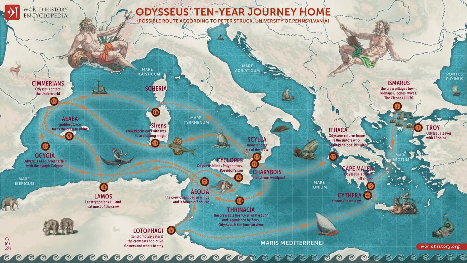
Posted by Kevin KearneyJul 13Explore a detailed map of Odysseus' fictional journey from 'The Odyssey.' Show 3 more findings ZoomMap of Odysseus’ 10-year Journey HomeWorld History Encyclopediahttps://www.worldhistory.org/image/15906/map-of-odysseus-10-year-journey-home/
Posted by Kevin KearneyMay 14, 2025How one biologist drew a national park's definitive mapLong before GPS, biologist John Cely mapped the swampy terrain of South Carolina's Congaree National Park by hand, and mostly from memory. The map was so accurate, it became the preferred resource for the park's rangers. This Atlas Obscura article explores how Cely acquainted himself with the park's particulars and how the map grew from an unofficial peculiarity into the park's definitive guide. ZoomAtlas Obscurahttps://www.atlasobscura.com/articles/congaree-national-parks-map?utm_source=Klaviyo&utm_medium=email&utm_campaign=Daily%20Newsletter%205%2F14&_kx=pG5YKPEZpDRsIinRvs98GMfnFaWgLFqXF-jgvAeQdAM.UUnqkC
Posted by Teddy BurkhardtSep 12, 2023Explore coral reefs in Google's "street view"Expanding its mission to map the world, Google Maps partnered with The Catlin Seaview Survey to introduce the first-ever underwater panoramas, making oceanic marvels like the Great Barrier Reef accessible to everyone. With Google Maps, the public... ZoomAbout - Google MapsCNBChttps://www.google.com/maps/about/behind-the-scenes/streetview/treks/oceans/
Posted by Teddy BurkhardtJan 14The Louisiana Purchase nearly doubled America’s size in 1803Acquired from France for $15M, the Louisiana Purchase added 828,000 square miles to the United States—stretching from the Mississippi River to the Rockies. US ambassadors in France signed the papers to buy the tract from the embattled Napoleon Bonaparte for a mere $15M before Jefferson learned the terms, due to the advantageous nature of the deal. 1:56CBS Sunday Morninghttps://www.youtube.com/watch?v=7xih15uENH0
Posted by Teddy BurkhardtSep 15, 2023Explore landforms that exist across America's national parksLandforms are not just scenic vistas; they are geological storytellers that shape ecosystems, climates, and our understanding of Earth's history. In this comprehensive look at landforms from the National Park Service, you will learn not only about different types of American landforms, but you will understand how these geological features are shaped by various forces, how they reveal an area's geological history, and how they influence climate and ecology. ZoomPark Landforms - Geology (U.S. National Park Service)National Park Servicehttps://www.nps.gov/subjects/geology/landforms.htm
Posted by Teddy BurkhardtSep 21, 2023Who was Ferdinand Magellan, and what did he do?Portuguese explorer Ferdinand Magellan left Spain on a trip to gather spices and circumnavigate the globe with five ships, more than 250 men, outdated maps, and a profound misunderstanding of the Pacific Ocean's width. Hear from a historian on... ZoomNot Just the Tudors - Magellan 500: The First Man to Sail the WorldGooglehttps://podcasts.google.com/feed/aHR0cHM6Ly9yc3MuYWNhc3QuY29tL25vdC1qdXN0LXRoZS10dWRvcnM/episode/NjMxYTBiOTk2YmY0ZmYwMDE0N2U1NTUw
Posted by Teddy BurkhardtAug 1, 2023Take a virtual tour through the Amazon BasinThanks to Google Maps’ Street View feature, people can virtually explore the Amazon River basin and its surroundings—part of the Amazon rainforest that is under the protection of the Brazilian government with restricted access to the public. The... ZoomGoogle EarthGooglehttps://earth.google.com/web/@-3.13609572,-60.49462966,39.40286458a,2601.39052365d,35y,165.14755431h,37.06879708t,0r/data=Ci8SLRIgNTIyYTlmZWIzNThkMTFlN2EzZDI3M2Q1NzNiYWZkZGMiCXJpby1uZWdybw
Posted by Teddy BurkhardtAug 4, 2023Take a virtual journey through the world's deserts with Google Earth and BBCExplore some of the world’s deserts in this “Natural Treasures” collaboration between Google Earth and BBC Earth. Visit the Namib Desert in Namibia where the simplest strategy to escape the heat is to emerge only in the cool of the night.... ZoomGoogle EarthGooglehttps://earth.google.com/web/@3.11212197,13.97345307,633.43236953a,16060500.81855836d,35y,0h,0.00040239t,0r/data=CjgSNhIgNThlZjM3NDAwOTk5MTFlNzkwZDU1MTRlOGNiMDZiODQiEmJiY19kZXNlcnRzX3NwbGFzaA
Posted by Kevin KearneyMar 10'Grand Canyon of the Yellowstone,' a work by American painter Thomas Moran, inspired Congress to establish Yellowstone National Park.Show 3 more findings 8:51The painting that inspired a National ParkSmarthistoryhttps://www.youtube.com/watch?v=MDgo9sMJxKs
Posted by Teddy BurkhardtJul 7, 2023The art of 'undiscovering' phantom islandsCenturies of maps include islands and isles that appear to only exist on atlases. This article explores the discovery and "undiscovery" of such landscapes, which still persist despite modern technology. As recently as 2012, Google Maps showed an... ZoomThese fabled ‘ghost’ islands exist only in atlasesNational Geographichttps://www.nationalgeographic.com/travel/article/these-fabled-ghost-islands-exist-only-in-atlases
Posted by Teddy BurkhardtAug 2, 2022Interactive human migration mapUsing archeological, genetic, and climate data, scientists have pieced together an outline of the human odyssey—the journey that took our species from Africa to all corners of the globe. Experience this 200,000-year migration using an interactive human migration map. ZoomInteractive Human Migration Map | PBS LearningMediaPBShttps://www.pbslearningmedia.org/resource/interactive-human-migration-map/interactive-map/
Posted by Kevin KearneyDec 16, 2025The 52-mile marvel of engineering inside Glacier National ParkGlacier National Park is home to over one million acres of natural beauty, but it also includes 52 miles of a manmade miracle in Going-to-the-Sun Road, which takes drivers on a majestic tour through some of the park's most breathtaking views. This brief history and photo gallery allows you to gain an appreciation for the incredible engineering behind the road’s construction. ZoomGoing-to-the-Sun Road - National Historic Landmark | Historic Montanahttps://historicmt.org/items/show/2850
Posted by Kevin KearneyJul 17Explore a collection of famous literary maps, including original images from 'Treasure Island,' 'The Swiss Family Robinson, ' and 'Walden.' ZoomHow Writers Map Their Imaginary WorldsAtlas Obscurahttps://www.atlasobscura.com/articles/writers-maps
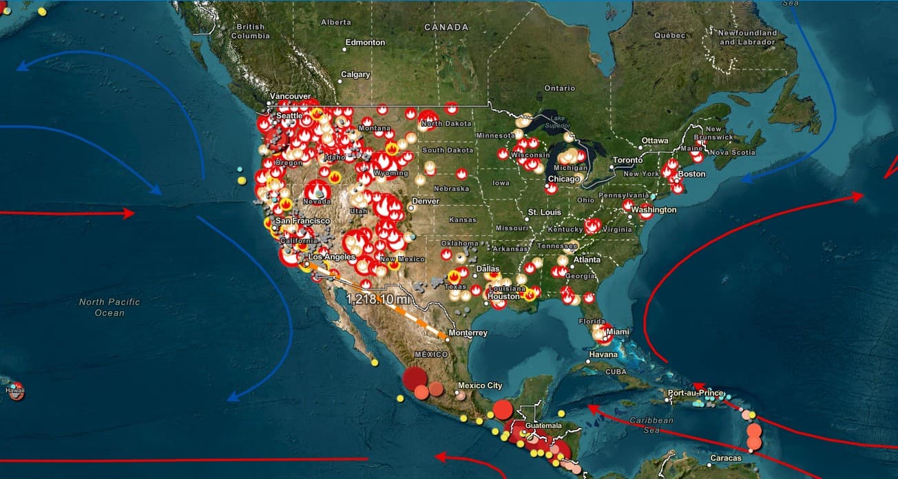
Posted by Marco Daniel MachadoSep 24, 2025Create digital maps of Earth with custom sketches and labelsIn this interactive, users can apply layers to various base maps to display natural and human features, including geological activity, biomes, ocean currents, population densities, and light pollution. Custom legends, markers, and drawings can be used to highlight prominent features. ZoomAtlasArcGIShttps://www.arcgis.com/apps/instant/atlas/index.html