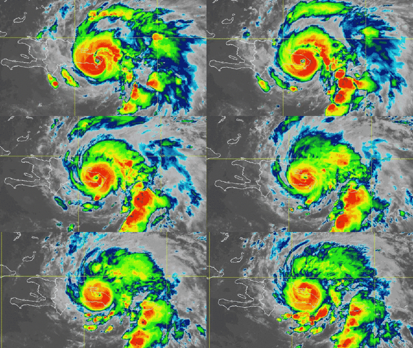
Posted by Marco Daniel MachadoFeb 20All hurricanes have a central eye, where no extreme weather occurs, surrounded by intense winds and thunderstorms.Show 4 more findings 4:25Inside The Sunny Center of a HurricaneMinuteEarthhttps://www.youtube.com/watch?v=gfPeAIDIgFs
Posted by Marco Daniel MachadoJun 3Hurricanes, which rely on air consistently spinning in the same direction, cannot cross the equator because air curves in opposite directions north and south of it.Show 5 more findings ZoomHurricanes never cross the equator. Here's why.Big Thinkhttps://bigthink.com/strange-maps/hurricanes-versus-equator/
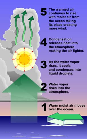
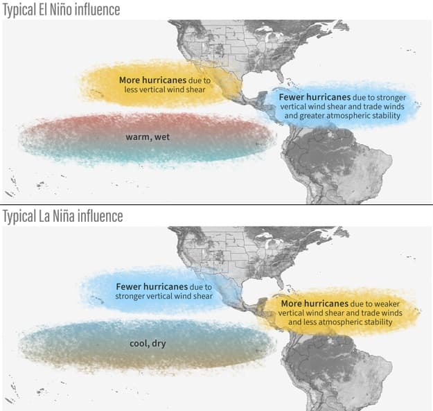
Posted by Marco Daniel MachadoNov 12, 2025Tropical cyclone formation require warm water and limited vertical wind shearOcean temperatures above 27 degrees Celsius fuel rising, moist air, which releases energy through heat as water vapor condenses into clouds. Significant changes in wind speed with height can spread out these upflows, preventing the eventual formation of a central column known as the eye. ZoomTropical Cyclone IntroductionNOAAhttps://www.noaa.gov/jetstream/tropical/tropical-cyclone-introduction
Posted by Marco Daniel MachadoMay 9, 2025Hurricanes spin due to differences in air and ground speed as they move across EarthThe movement of an object across latitudes causes it to take a curved trajectory because its speed no longer matches that of the ground beneath it. This phenomenon, called the Coriolis effect, explains why hurricanes spin counterclockwise in the Northern Hemisphere and clockwise in the Southern Hemisphere. 2:02The Coriolis Effect Explainedhttps://www.youtube.com/watch?v=HIyBpi7B-dE
Posted by Marco Daniel MachadoMay 9, 2025Hurricanes can grow by replacing their eyewallA second outer eyewall can form around the primary eyewall surrounding a hurricane's eye. During an eyewall replacement cycle, the outer wall can weaken, collapse, and replace the inner wall, temporarily weakening the storm before it strengthens and grows. 2:02Eyewall Replacement Cycles Inside Hurricaneshttps://www.youtube.com/watch?v=7sZyAjcFwmY
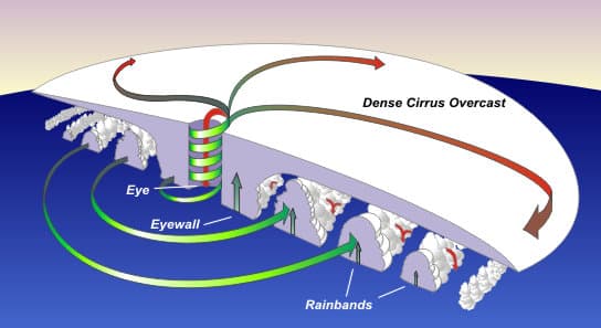
Posted by Marco Daniel MachadoMay 16, 2025Tropical cyclones consist of three main parts: the eye, the eyewall, and rainbandsThe eye is a calm, clear central area surrounded by an eyewall of intense thunderstorms. Rainbands are spiral bands of clouds and thunderstorms extending from the eyewall. ZoomTropical Cyclone StructureNOAAhttps://www.noaa.gov/jetstream/tropical/tropical-cyclone-introduction/tropical-cyclone-structure
Posted by Teddy BurkhardtJun 30How do hurricanes form?Tropical cyclones, also called hurricanes and typhoons, cause catastrophic damage when they strike land. This four-minute video explores the life cycle of cyclones—how atmospheric conditions, ocean temperatures, and the Earth's rotation combine to create them, and how they are driven by winds and eventually weaken after moving over land. 3:42Formation Of A Tropical Cyclonehttps://www.youtube.com/watch?v=UKL9NIxLIIE
Posted by Marco Daniel MachadoAug 24While hurricane frequency has not increased over the past century, average hurricane intensity has, which scientists attribute to rising air and ocean temperatures.Show 4 more findings ZoomHow climate change affects hurricanes, typhoons and cyclonesLimited AccessBBChttps://www.bbc.com/news/articles/cz913gxlw3jo
Posted by Marco Daniel MachadoFeb 18The risk of tornadoes and storm surges is greatest on the 'dirty side' of a hurricaneWinds in the right-front quadrant of the storm are amplified by the hurricane's motion and its rotation, which both move air in the same direction. Upon making landfall, these winds pull water from the Gulf and Atlantic onto land, creating storm surges. Tornadoes can also be generated from large differences in wind speed and direction at various heights. 5:05The "dirty side" of a hurricane, explainedVoxhttps://www.youtube.com/watch?v=G8SK6e8I01Y
Posted by Marco Daniel MachadoJul 31By absorbing 90% of the thermal energy trapped by greenhouse gases, oceans are providing increasingly more energy to power the rapid strengthening of hurricanes.Show 3 more findings 7:21How climate change is changing hurricanesThe Weather Channelhttps://www.youtube.com/watch?v=lpkqVkxLM2g
Posted by Teddy BurkhardtJun 30What does the hurricane forecast cone really tell us?Ever feel like hurricane forecasts change a lot? Hurricane forecast tracks might not mean what you think they do. Concentric circles are actually used to help form the forecast. Chief Meteorologist Bobby Deskins explains how you should really be reading these cones. 2:52What hurricane forecast cones actually mean | Weather Explainerhttps://www.youtube.com/watch?v=Hme8Pn4lXv0
Posted by Marco Daniel MachadoMay 7, 2025Why aren’t there hurricanes in Europe?Despite their proximity to the Atlantic Ocean, the effects of the subtropical jet stream make tropical storms and hurricanes unlikely to reach Europe at full strength. Their remnants, however, can combine with other weather systems to create powerful storms. 3:03Why Hurricanes Hardly Ever Hit Europehttps://www.youtube.com/watch?v=Q1JeRQnpkM0&ab_channel=InsiderScience
Posted by Teddy BurkhardtJul 15, 2022How does climate change impact hurricanes?Statistical relationships between sea surface temperature and hurricanes, analysis of century-scale Atlantic tropical storm and hurricane records, analysis of other observed Atlantic hurricane metrics, and more. ZoomGlobal Warming and Hurricanes – Geophysical Fluid Dynamics LaboratoryNOAAhttps://www.gfdl.noaa.gov/global-warming-and-hurricanes/
Posted by Marco Daniel MachadoJun 30The cone of uncertainty predicts where a hurricane's center can potentially travelA common misconception is that regions beyond the cone are safe, but the spread does not depict the full reach of a cyclone's wind, rain, or storm surges. The cone is not built from real-time storm data but is an average forecast error from the past five years.Hurricane Forecasting 101 - Science Quickly | Podcast on SpotifySpotifyPinnedCalifornia Consumer Privacy Act (CCPA) Opt-Out IconBack ButtonSearch IconFilter IconScience Quicklyhttps://open.spotify.com/episode/1RQLQza7jBmmwtFHbWlUIs
Posted by Marco Daniel MachadoJul 31Rapid intensification is the increase in a hurricane's sustained wind speed by at least 35 miles per hour within 24 hours, which can strengthen it by up to two categories.Show 2 more findings ZoomRapid intensification: How hurricanes gain strength and why it's so dangerousAccuweatherhttps://www.accuweather.com/en/hurricane/rapid-intensification-how-hurricanes-gain-strength-and-why-its-so-dangerous/1690019
Posted by August MoonJun 2, 2025Watch how scientists learn about hurricanes by flying into themA specialized fleet of Air Force planes is built to fly into hurricanes and gather critical data from inside the storm. Beyond radar and microwave sensors, the planes are equipped with dropsondes—small instruments dropped into storms to measure pressure, temperature, and wind. 1:11How We Track and Monitor Hurricanes1440 Originalshttps://www.youtube.com/shorts/X03EwiZcGyI
Posted by Marco Daniel MachadoMay 27The way hurricanes are categorized may mislead the public to their dangersThe Saffir-Simpson scale categorizes hurricanes based on wind speed, but tropical cyclones' main dangers are storm surges and heavy rainfall. To better communicate risks to the public, a new system that incorporates hurricane size, water content, and other complexities should be developed. ZoomWhy we need a better way to measure hurricanesBBChttps://www.bbc.com/future/article/20240822-why-we-need-a-better-way-to-measure-hurricanes
Posted by Marco Daniel MachadoMay 16, 2025Storm surges, not winds, are the leading cause of hurricane-related fatalitiesA storm surge is an abnormal rise in water levels generated by a storm that exceeds predicted tides. It is particularly dangerous in coastal regions, where it can generate extreme flooding well before the hurricane makes landfall. ZoomStorm Surge OverviewNOAAhttps://www.nhc.noaa.gov/surge/
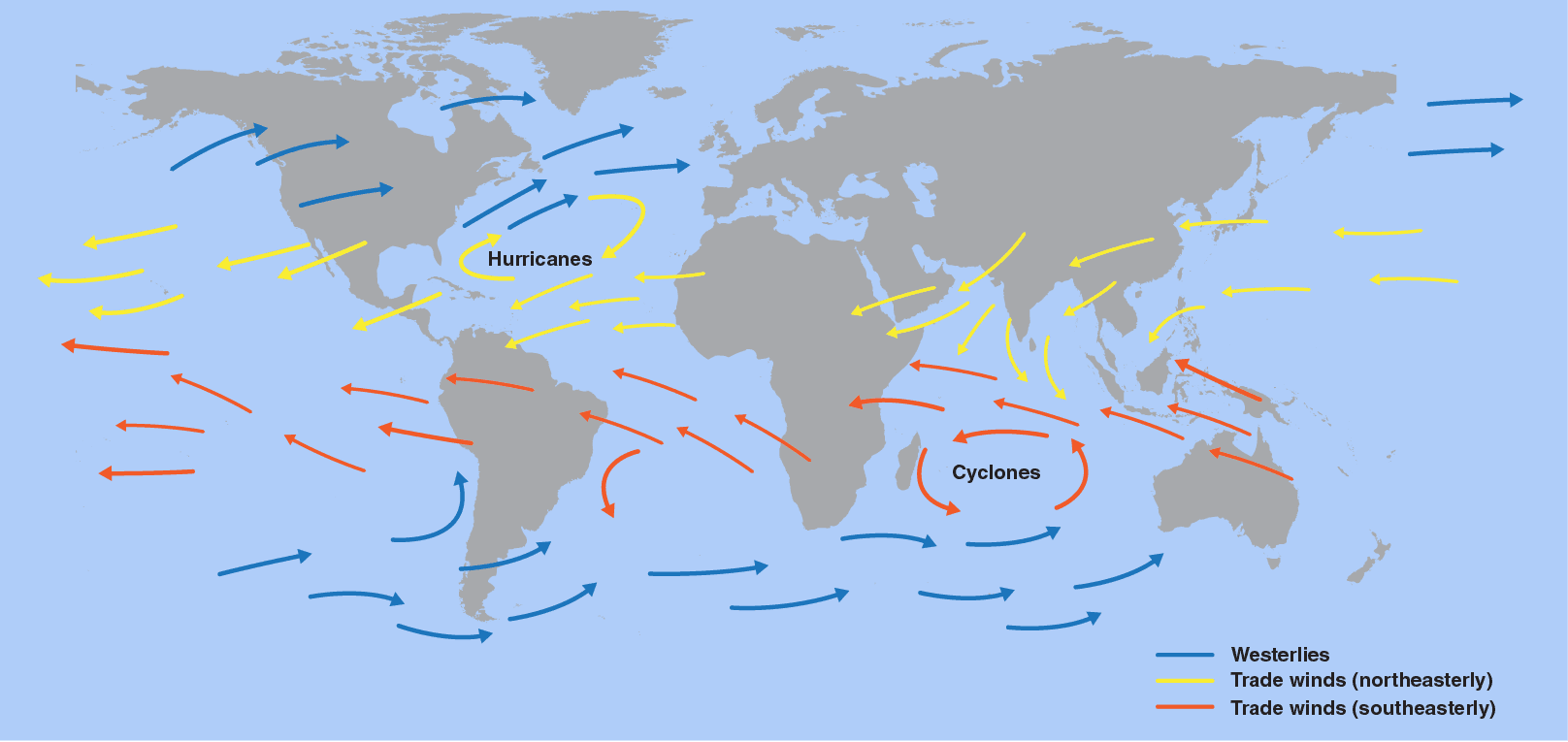
Posted by Marco Daniel MachadoMar 18Trade winds blow from east to west due to the Coriolis EffectWarm air rises near the equator while cooler air sinks near the poles, creating circulation patterns that curve due to Earth's rotation. At the equator, doldrums—calm regions of no wind—build warm, moist air, creating storms. ZoomTrade WindsNOAAhttps://scijinks.gov/trade-winds/
Posted by Marco Daniel MachadoMay 16, 2025Hurricanes are classified according to their maximum sustained wind speedThe Saffir-Simpson Hurricane Wind Scale is a rating system that organizes hurricanes into one of five categories. Categories three and higher are classified as major hurricanes, but all categories can produce deadly storm surges and rain-induced floods. ZoomSaffir-Simpson Hurricane Wind ScaleNOAAhttps://www.nhc.noaa.gov/aboutsshws.php
Posted by Marco Daniel MachadoMay 16, 2025A list of common questions and answers about hurricanes from NOAAThis FAQ answers many questions hurricane researchers at NOAA have received, sorted by category. The answers provide insights into hurricane classification and naming, forecasting their movement and growth, and tips for preparing ahead of landfall. ZoomHurricanes Frequently Asked QuestionsNOAAhttps://www.aoml.noaa.gov/hrd-faq/
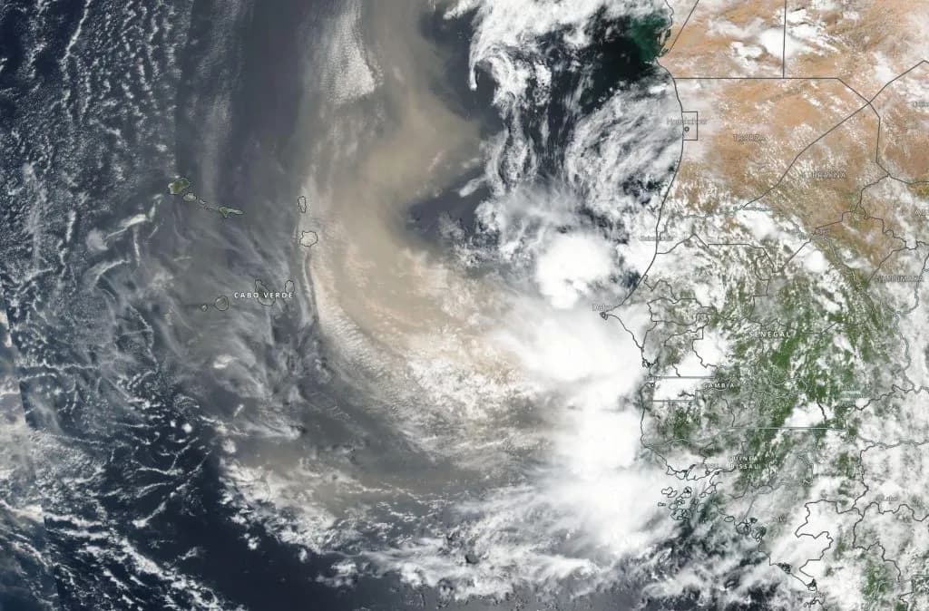
Posted by Marco Daniel MachadoMay 16, 2025Dust from the Sahel and Saharan regions makes northwest Africa a hurricane nurseryNASA’s Convective Processes Experiment—Cabo Verde studied the early stages of hurricane formation, identifying how dust interacts with clouds over the ocean to produce the rainy disturbances that become tropical cyclones. ZoomIn Dust and Clouds Over Africa, Scientists Find Clues to How Hurricanes FormNASAhttps://science.nasa.gov/blogs/earth-expeditions/2023/05/24/in-dust-and-clouds-over-africa-scientists-find-clues-to-how-hurricanes-form/
Posted by August MoonAug 6, 2025Violent storms and crushing pressure await those inside Jupiter’s Great Red SpotAs seen from space, Jupiter’s most striking feature is an anticyclone 30% larger than Earth, with winds twice the speed of Category 5 hurricanes. The descent into the storm brings enough pressure to strip atoms of their electrons. 1:17What Would Happen If You Fell Into Jupiter's Great Red Spot?1440 Originalshttps://www.youtube.com/shorts/tcyuyUP98u8
Posted by Marco Daniel MachadoFeb 20Hurricane conditions are created in a University of Miami wind-wave tankThe SUrge-STructure-Atmosphere INteraction Wind Wave Laboratory contains a 38,000-gallon wave pool connected to a wind tunnel that can generate air currents of up to 155 mph. SUSTAIN allows scientists to study how the atmosphere interacts with the ocean in extreme weather. 12:12Inside a Category 5 Hurricane Simulatorhttps://www.youtube.com/watch?v=g4SjaZb1AIM
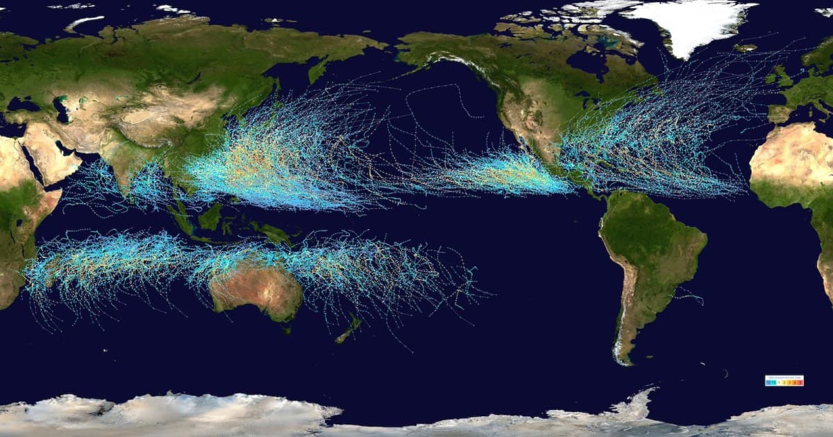
Posted by Marco Daniel MachadoMay 27Tropical cyclones are called hurricanes, typhoons, and cyclones around the worldTropical cyclones are named differently based on their region of origin due to historical traditions and cultural importance. These storms are called hurricanes in the Atlantic and northeast Pacific oceans, cyclones in the southwest Pacific and Indian oceans, and typhoons in the northwest Pacific Ocean. ZoomHurricanes, Cyclones and Typhoons: What's in a Name?NOAAhttps://www.nesdis.noaa.gov/news/hurricanes-cyclones-and-typhoons-whats-name
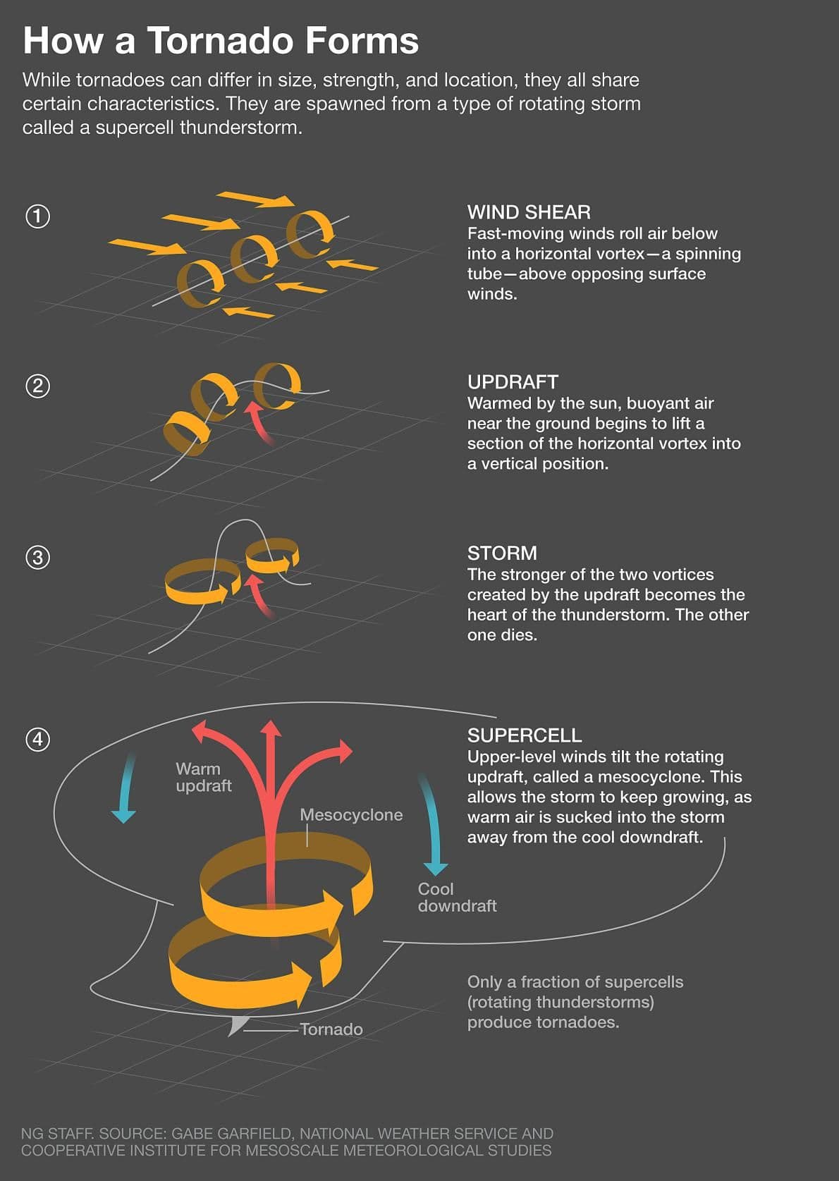
Posted by Marco Daniel MachadoFeb 18Tornado formation relies on wind shear to create a tube of rotating airOnce a horizontal vortex is created by air circulating between winds of different directions and speeds, an updraft, such as those seen in powerful thunderstorms, tilts the vortex vertically. The updraft then strengthens the vortex, which becomes a tornado upon touching the ground. Zoomb5db4c22374db159735597f682055ea4.jpg (1190×1675)https://lah.elearningontario.ca/CMS/public/exported_courses/CGF3M/exported/CGF3MU02/CGF3MU02/CGF3MU02A05/_images/b5db4c22374db159735597f682055ea4.jpg
Posted by Marco Daniel MachadoJan 15Atmospheric processes amplify the strength of storms by coalescing cloudsResearch has shown that turbulent mixing of air at the edges of clouds and other small-scale thermal activity beneath them help clouds group together, intensifying short bursts of rainfall, especially in tropical regions. Simulations reveal this produces more powerful storms than predicted by older models, though they may occur less frequently. ZoomWhen clouds flock togetherhttps://knowablemagazine.org/content/article/physical-world/2025/physics-of-clumping-clouds-extreme-rainfall
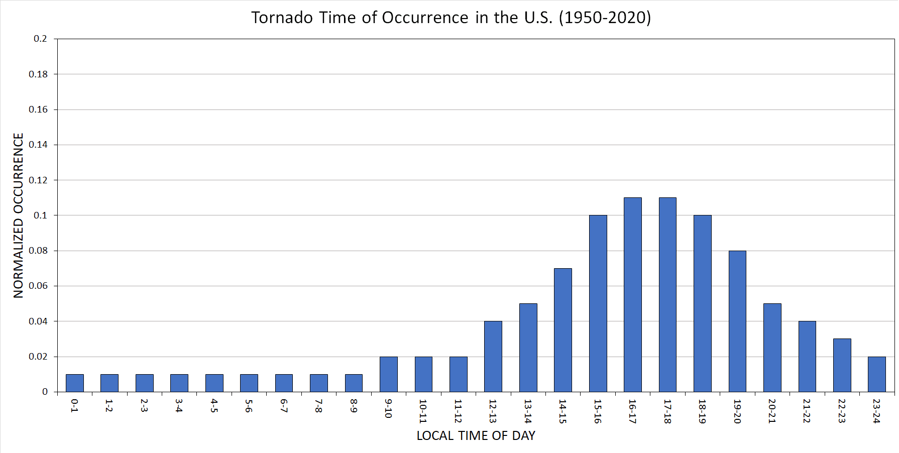
Posted by Marco Daniel MachadoFeb 18Most tornadoes occur during the afternoon and evening hoursWhile there is no official national tornado season as with Atlantic hurricanes, many tornadoes form in the presence of thunderstorms, which are fueled by solar heating and the energy released by the condensation of water vapor. The airflow instabilities created from this energy build throughout the day until the sun sets. ZoomNOAAhttps://www.ncei.noaa.gov/access/monitoring/tornadoes/patterns
Posted by Marco Daniel MachadoJan 9Lightning storms are more common in coastal and tropical regionsWater-abundant areas that receive increased solar radiation, such as those near the equator, experience increased rates of evaporation, which produce tall clouds as moisture rises, cools, and condenses. Mountain ranges can also steer air to higher altitudes, creating collisions between atmospheric particles that generate charge imbalances—the precursors to lightning.Ologies with Alie Wardhttps://open.spotify.com/episode/5GZEZY6myvHTJT0piQpO6n
Posted by Marco Daniel MachadoFeb 18Tornadoes, or twisters, have been seen on every continent but AntarcticaBecause tornadoes require rising warm air to form, some meteorologists have suggested that urban environments—locations where human landscape modification has introduced materials that trap thermal energy—can enhance the conditions needed for tornado formation. Tornadoes have been reported to cause ear "popping" due to drastic changes in air pressure.Smithsonian Magazinehttps://www.smithsonianmag.com/science-nature/ten-amazing-facts-about-tornadoes-explained-180984051/
Posted by Teddy BurkhardtDec 4, 2025Small elevation differences drastically protect homes in hurricanesThe construction of seaside homes has long involved building residences on elevated stilts, but this feature adds costs—and some elevated homes still fail. Explore the engineering behind the ideal height of a hurricane-proof building. 22:04Hurricane vs. Tiny Houseshttps://www.youtube.com/watch?v=-2HSFJOzQQ8
Posted by Marco Daniel MachadoAug 5Horsehead-shaped features seen on the sun and the clouds of Earth and Jupiter are examples of Kelvin-Helmholtz instabilities, where a faster-moving fluid rolls atop a slower-moving fluid.Show 3 more findings 4:32Amazing Clouds and the Kelvin-Helmholtz Instability - Sixty SymbolsSixty Symbolshttps://www.youtube.com/watch?v=qgamfo86FQo
Posted by Marco Daniel MachadoApr 2How jet streams, which reside in the troposphere, shape and confine pockets of atmospheric airThese fast-flowing ribbons of air are hundreds of kilometers wide and typically travel from west to east due to Earth's rotation, with the polar front and subtropical jets serving as major drivers of global circulation. Warmer air near the equator pushes the polar front jets toward the poles, which can buckle and deform them as they contain frigid polar vortex systems. 5:26Met Officehttps://www.youtube.com/watch?v=Lg91eowtfbw
Posted by Marco Daniel MachadoMay 7, 2025The NOAA has a specialized team of researchers that fly directly into hurricanesThe reconnaissance missions gather data for computer models to forecast hurricanes and improve disaster preparedness. Each flight can last eight to ten hours and uses a specialized Air Force fleet. 2:02Watch NOAA's Hurricane Hunters Fly Into the Eye of a MonsterNOAAhttps://www.youtube.com/watch?v=70n7riR6fCM
Posted by Marco Daniel MachadoMay 17, 2025What is the cone of uncertainty?In hurricane forecasting, the cone of uncertainty results from connecting a set of circles representing where a hurricane is expected to be at 12-hour intervals. The size of each circle is two-thirds of the historical forecast error over the previous five years. ZoomForecast Cone Of Uncertainty: Facts And Mythshttps://weather.com/safety/hurricane/news/2024-05-31-hurricane-forecast-path-cone-facts-myths
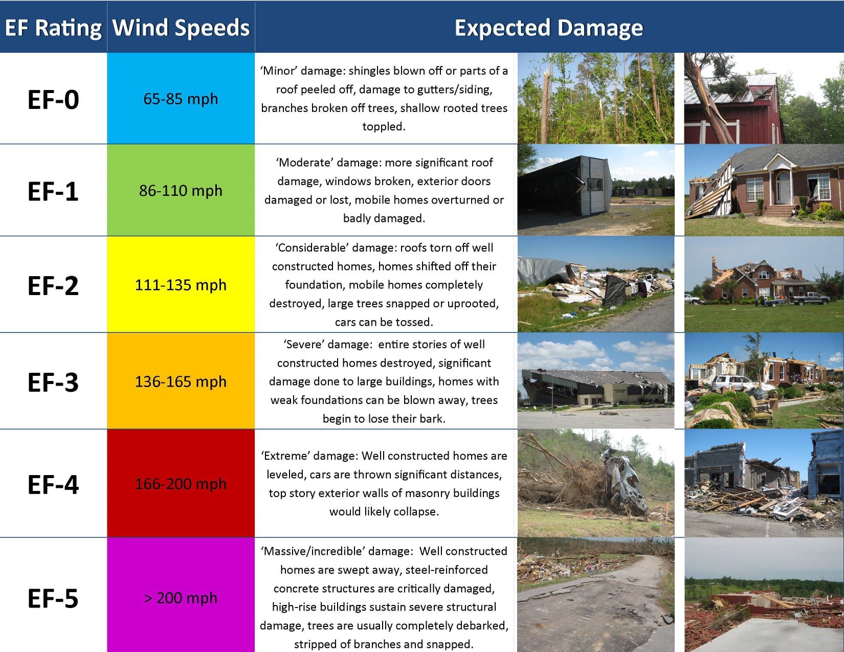
Posted by Marco Daniel MachadoFeb 18Various types of tornadoes are distinguished by their shape, size, and locationWaterspouts form over water as long, thin columns of mist and air, while elephant trunks are tornadoes that elongate vertically as they become tilted during their formation, resembling the mammal's appendage. Wedge tornadoes are among the most powerful, often spanning a mile or more in width. Zoomhttps://www.accuweather.com/en/severe-weather/10-types-of-tornadoes-that-occur-in-the-us/1514270
Posted by Marco Daniel MachadoMay 16, 2025Check out hurricane history where you liveThe NOAA's historical hurricane tracker lets you explore over 150 years of data to see where hurricanes traveled and made landfall. The tool lets you search by location, name, or year; create maps and tables; and read NOAA storm reports. ZoomNOAA Historical Hurricane TracksNOAAhttps://oceanservice.noaa.gov/news/historical-hurricanes/
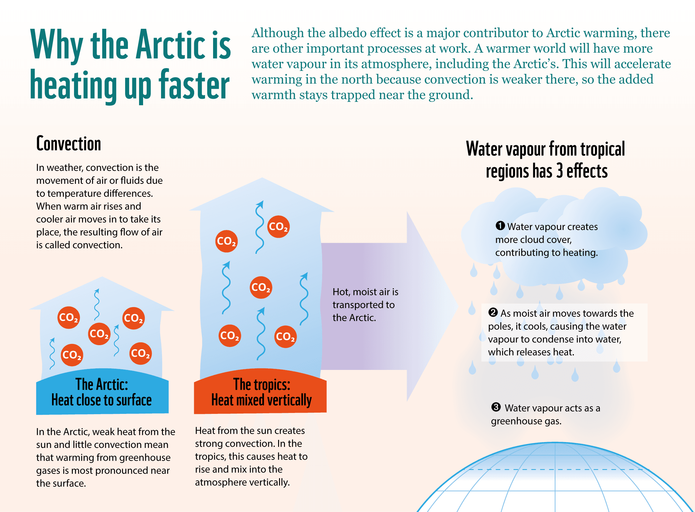
Posted by Marco Daniel MachadoAug 6The Arctic warms more quickly than the rest of the planet because of the loss of surface ice, a lack of vertical air circulation, and the release of thermal energy as water vapor condenses.Show 3 more findings ZoomWhy is the Arctic warming faster than the rest of the planet? - WWF ArcticWorld Wildlife Fundhttps://www.arcticwwf.org/the-circle/stories/why-is-the-arctic-warming-faster-than-the-rest-of-the-planet/
Posted by Marco Daniel MachadoFeb 18Though less common, tornadoes can form without the presence of thunderstormsSupercell tornadoes involve rising warm air—updrafts—from the strongest type of thunderstorm—supercells—to help turn horizontally rotating tunnels of air into vertical columns. In non-supercell tornadoes, which are generally weaker as a result of forming within less energetic systems, vertical rotation is present from the start near ground level. 5:32National Geographichttps://www.youtube.com/watch?v=aacHWoB7cmY